MASTER THE FUTURE OF GEOAI
GeoAI Certificate Programme
From GIS Basics to AI-Powered Geospatial Analysis
Starting Date – 17 September, 2026
About The Course
The GeoAI Certificate Programme offered by the MERI Department of Space Studies (DSS) is a four-week, instructor-led programme designed to build practical skills in Geographic Information Systems (GIS), Remote Sensing, and AI-powered geospatial analysis. Beginning with cartographic fundamentals and progressing to advanced GeoAI applications, the programme combines structured theory with guided laboratory sessions to create a comprehensive learning experience.
Participants gain hands-on experience using leading open-source geospatial technologies while working with real satellite datasets and practical workflows. Each of the twelve sessions concludes with a measurable outcome such as maps, scripts, analytical models, or interactive applications, allowing learners to develop practical GeoAI capabilities through continuous application and project-based learning.
- Beginner-friendly with no prior GIS or coding experience required.
- Every session delivers a practical, industry-relevant output.
Register Now
Course Structure
4
WEEKS
3
DAYS/WEEK
12
SESSIONS
2 HRS
PER SESSION
24
CONTACT HOURS
Mode of Delivery: Instructor-Led, Lab-Based (In-Person / Hybrid)
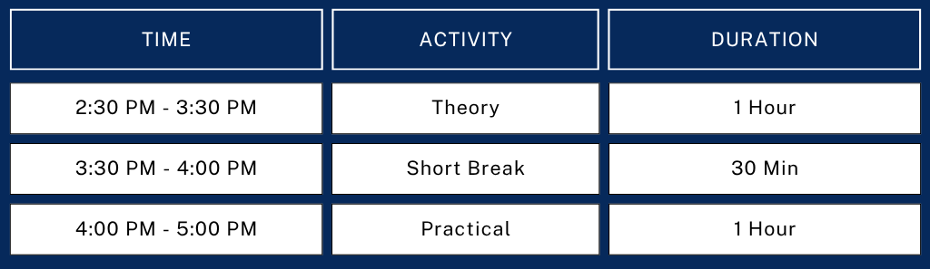
Weekly Class Schedule
Every Thursday, Friday & Saturday
Who Should Attend
Zero prior experience needed. We start from first principles, no GIS or coding background required.

You're an undergrad
Wanting a real technical edge for placements & research.
You're a postgrad / researcher
Adding spatial AI to your specialization.
You're a working professional
Acquiring new skills in GeoAI, with domain specialisation in geospatial / GeoAI roles.
You're in defence
Keen to apply GeoAI to real operational problems & geospatial intelligence.
You work in government
Using GeoAI for infrastructure development and capacity enhancement.
You're new to GeoAI
Acquiring additional skills as a budding engineer, architect or industry/corporate professional.
Why This Programme Is Different?
Session-by-session design
All 12 sessions build directly on the last, from first map to capstone.
Every class produces an output
No theory-only sessions: each ends with a map, script, model or app.
Full open-source toolkit
QGIS, Python, GeoPandas, Rasterio, Earth Engine & more, at zero cost.
Real datasets throughout
Sentinel-2, Landsat, SRTM DEM & OpenStreetMap in every practical.
Session-by-Session Curriculum
12 sessions · 4 weeks · every session ends with a real, error-free, inspectable output
Geographic & Cartographic Foundations
Maps, scale, CRS & lat/long; install & tour QGIS, load vector layers, pan/zoom.
Remote Sensing & Satellite Imagery
Raster vs. vector, spatial/spectral/temporal resolution; source Sentinel-2 & Landsat imagery.
Raster Processing, Band Math & Spectral Indices
Band math, NDVI/NDWI/NDBI; compute indices, build a false-colour composite.
Vector Spatial Analysis
Buffer, clip, overlay, dissolve, joins; run a buffer & spatial join analysis.
Georeferencing, Digitization & Terrain Analysis
Georeferencing, DEMs, slope/hillshade; digitize a toposheet, build a terrain map.
Python for GIS: PyQGIS & Automation
PyQGIS API & automation; script batch-reprojection & buffer-export workflows.
Spatial Data Engineering
GeoPandas, Rasterio & intro to PostGIS; manipulate shapefile & raster data in Colab.
Web GIS & Interactive Mapping
Web GIS architecture, GeoJSON, Leaflet; publish a Folium map with pop-ups.
Machine Learning Foundations for GeoAI
AI/ML/DL overview, ML workflow; explore Earth Engine, prep a labelled dataset.
Image Classification & Land Cover Mapping
Random Forest classification, LULC principles; run a classification in Colab.
Deep Learning for GeoAI
CNNs, object detection & change detection; compare before/after imagery.
GeoAI Applications & Capstone Presentation
Real-world applications, LLMs & GeoAI agents, prompt engineering; present capstone.
Toolkit, Assessment & Careers
Software & Tools Covered
QGIS
Google Earth Pro
Google Colab
Python
GeoPandas
Rasterio
Folium
Leaflet
OpenStreetMap
Sentinel Hub
USGS Earth Explorer
Google Earth Engine
PostGIS
GitHub
Scikit-learn
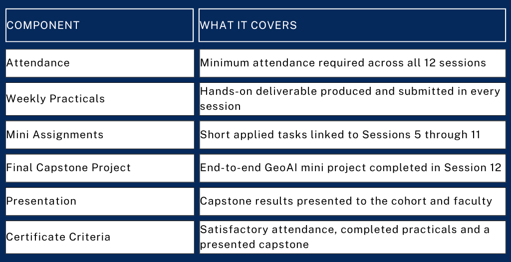
Assessment & Certification
Where It Leads
GIS Analyst
GeoAI Engineer
Spatial Data Analyst
Agriculutural GIS Analyst
Research in GeoAI / Earth Observation
Remote Sensing Analyst
Geospatial Data Scientis
Urban GIS Consultan
Defence GIS Analyst
Higher Studies (M.Tech / MS / PhD)
Venue
MERI Group of Institutions, Janakpuri, New Delhi
Organized by: MERI Department of Space Studies